Inpho UAS Processing Product
Best Drone Data Processing Software
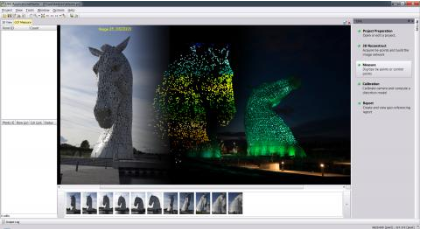
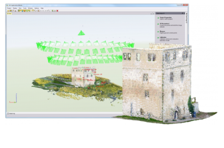
UUASMaster Inpho software is the best drone data processing software which is available in the market. Here find the key features of the drone data processing software. A complete photogrammetric workflow (georeferencing, dense point clouds, true orthophotos, 3D textured meshes, orthomosaics and digitized vectors) combined in one single product. Quick black-box or multi-step processing with quality-optimized or performance optimized parameter presets including full featured refinement and editing tools. Process data from any type of UAS and frame cameras – with or without additional data. Excellent results without requiring specialized photogrammetry knowledge or experience. Also available integrated into Trimble Business Center Photogrammetry Module including all survey tools combined with survey hardware and GNSS base-line processing.
- Overview
- Features
- Highlights
- Options
- Support & Maintanance
- Whats's New
- Based on state-of-the-art Trimble Inpho technology, known. for 30 years of digital aerial
- photogrammetry leadership the new UASMaster module is bridging the gap between simple near
- black-box workflows for non-photogrammetrists and photogrammetry expert workflows.
- It combines very intuitive guided workflows with flexibility, highly effective interactive editing tools and thorough quality assurance reports required by the advanced user.
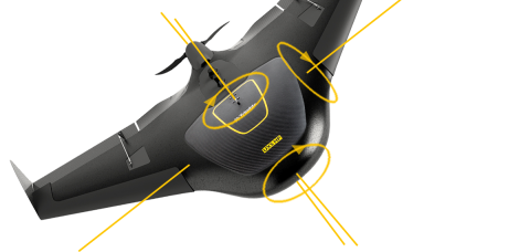
- UASMaster has an open market concept and therefore is able to process data from almost every hardware vendor for UAS. It works with fixed-wing vehicles as well as with helicopter-type aircraft. This best drone data processing software proved successful in processing even with hand-held cameras, survey balloons, and other types of unmanned aerial systems.
- UASMaster includes advanced technology that has been customized to provide high-quality results from the special characteristics of UAS data. The incorporation of specialized computer-vision algorithms produces very accurate results automatically, with minimal manual interaction. Optimized processing is available for UAS with GPS support and high-quality direct-georeferencing (e.g. with Applanix APX-15). This ensures a stable and reliable photogrammetric system delivering excellent results without requiring specialized photogrammetry knowledge or experience.
Complete Photogrammetric Workflow in One Product:
- Full automatic geo-referencing, calibration, refinement, and analysis.
- Create colorized dense point clouds, surface models, and bare earth terrain, models.
- Refine and edit terrain models, collect GIS data and vector maps on top of stereo 3D imagery.
- Create digital orthophotos, classic orthos as well as true orthos.
- Generate imaging point clouds as a cost-effective alternative to laser scans, benefit from detailed images to acquire GIS data and transfer most of your survey work to the convenience of your office. UAS Master combines ease of use with the full power of a photogrammetric workstation.
- This best drone data processing software bridges the gap between simple near black-box workflows for non-photogrammetrists and photogrammetry expert workflows. UAS Master includes advanced technology that has been customized to provide high quality results from the special characteristics of UAS data. It easily integrates into the Inpho world of photogrammetry, into Trimble Business Center as well as into many 3rd party workflows
Highlights of UASMaster Drone Data Processing Software
Modern computer-vision algorithms combined with proven state-of-the-art photogrammetric techniques produce accurate results automatically, with minimal manual interaction:
- Open for any fixed-wing, multi-copter or handheld frame camera
- Special support for high-quality GNSS/IMU data for stable processing in challenging conditions or to eliminate need for ground control.
- Intuitive guided workflow concept for the photogrammetric novice which perfectly integrates into any photogrammetric workflows.
- + Fully compatible with Inpho photogrammetry modules from Trimble.
- Streamlined workflow to automatic feature extraction with eCognition and perfect integration into Trimble Business Center for classic survey applications.
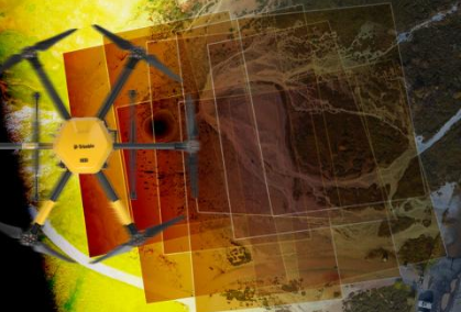
Area Mapping Projects
- Interactive context-driven and automated editing capabilities for geo-referencing and point clouds including morphological data creation (e.g. break-line measurements), classification, filtering, and many more.
- + UAS-specific local-area ortho editing tools Expert tools, simplified for Non-photogrammetrists such as automatic correlation-based terrain following, enabling precise stereoscopic measurements without requiring stereo-experience.
- Complete engineering workflows including CAD tools, contouring, and gridding.

- Network licensing for all options with network dongle Monthly rental, updates, and upgrades from lite
- Alternative entry-level lite version available (limited to 800 images, no point cloud editing capability) including all high-quality georeferencing, point cloud matching, and ortho capabilities.
- Optionally available integrated into Trimble Business Center Photogrammetry, TBC-HCE, Spectra Precision Survey Office for complete survey-type workflows.
- Maintenance (Ist year included in software price) includes support and version updates.
- Ask our sales team about special education and research offerings.
- Automatic feature extraction with Trimble eCognition.
- Direct stereoscopic 3D mapping into CAD and GIS is available through the connection to Summit Evolution.

- Support & Training Trimble Inpho software is accompanied by outstanding technical support and effective training by expert photogrammetrists. Each module comes with one year included maintenance.
- (software updates and support included) that can be extended on a yearly basis.
- Highly-skilled support engineers provide knowledgeable operators for smooth and efficient production. Basic photogrammetry training, as well as expert training, are available. Training is available as trainer-led online classroom training, as well as online personal training. Or, let us train your staff directly in your office, or here at Trimble. No problem if you have a tight schedule, we also offer self-paced learning courses with regular online Q&A sessions.
- Consulting Let us help you optimize your photogrammetric production workflow. Our engineers are prepared to analyze current bottlenecks in order to improve the quality, efficiency, and productivity of your projects.
- Software Maintenance with the drone data processing software update service we guarantee that your production environment stays up-to-date. Software maintenance agreements are free for the first 12 months after a new license has been purchased, after that, maintenance contracts can be renewed on an annual basis. Maintenance includes the update service, as well as access to our technical support.
Trimble is pleased to announce a new version of UASMaster. This version leverages the latest photogrammetric processing technology to generate highest precision point clouds and orthophotos from UAS imagery.
The new capabilities include:
- 3D Georeferencing: Enhanced flexibility in supporting all varieties of UAS platforms including: fixed wing nadir, multi-copter oblique and hand-held imagery datasets – even with arbitrary (flight) paths.
- © 3D Reconstruction: Automatically extract high quality 3D point clouds from multiple platform types. Choose the best UAS platform for your project and generate the same high quality deliverables for your clients. This provides new capabilities for applications such as building facade mapping, cell tower reconstruction, monitoring of vertical structures, bridges and many more.
- Automated Project Setup: This drone image processing software significantly improved ease of use and reduced processing time. Simply import imagery and start processing: camera and EXIF information is automatically read from the imported files and added into the project setting for the
// Drop us a line! We are here to answer your questions 24/7
